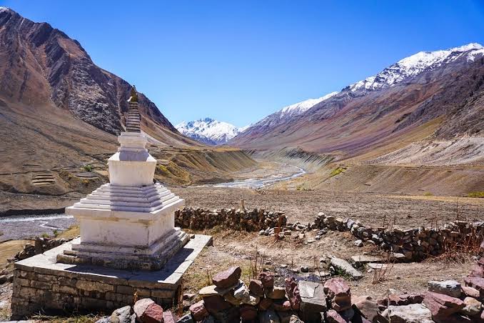
Pin Parvati Pass is named after the pass link of Parvati Valley of Kullu to Pin Valley in Spiti. The journey starts from Kullu and ends in Manali taking 11 days adventurous trip. The exciting part of this trek falls in the abundant beauty of nature with attractive landscape, lush greenery, intense alpine forest, wild colorful blossoming flowers and north terrestrial sceneries. The trekking starts from driving to Barsheni Village from Kullu. While trekking to Rudranath and camp followed by Khirganga to Tunda Bhuj and Thakur Kuan at height of 13400 high trekkers discover the barren valleys of Himachal, attractive villages, bright sea cliff, and high chilling waterfalls. Khir Ganga is devoted to lord Shiva where devotees takes a deep bath in hot tank water. The pass gives a striking view on one side of a colorful hue of mountains flanked by the snowy peaks and the barren Spiti valley on the other
Pin Parvati Pass
Rs 30,100.00 / Per person
- Region :Himachal Pradesh
- Altitude:17500 ft.
- Duration:11 Days
- Distance :110 Km
- Difficulty :Difficult
- Best Time :May to June
Basics Gears
• Backpack & Rain Cover (40-60 Litres)
• Trekking Shoes
• Trekking Pole
• LED Torch
• One Water Bottle (one litre)
• Basic Medications (or prescribed if any)
Clothes
• Trekking Jacket
• Three (Five in winter) Warm Layers
• Two trek pants (one Wear and one carry)
• Two collared t-shirts
• Thermals
Accessories
• Sunglasses
• Sunscreeen Lotion (SPF 50/70)
• Lip Balm (SPF 30)
• Sun cap
• Synthetic hand gloves
• Two pair of Socks
• Raincoat/Ponchos
Others
• Daypack (20 litres), if you opt to offload your backpack
• Toiletries
• Cutlery
• Plastic cover (for wet clothes)
Mandatory Documents
Original and photocopy of government photo identity card- (Passport, Aadhaar Card, Driving license or voters ID, Medical Certificate)
Day 1: Report in Bhuntar. Road drive from Bhuntar to Barsheni
Report at Bhuntar bus stop at 11:00 AM. From Bhuntar road distance to Barsheni is about 48 Kms and should take about 2 hours. Barsheni is the nearest road head for this trek which is also a Dam site. Stay in Hotel/Guest house on Sharing basis in Kalga which is around 15 minutes hike from last road head of Barsheni.
Day 2: Kalga - Kheerganga - 2810m - 6 hours
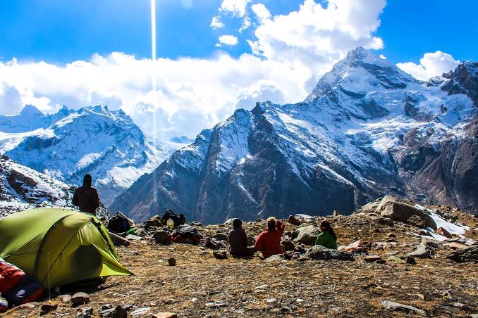
Pin Parvati Pass trek starts from Kalga. In the beginning, trail descend sharply till you reach the riverbed thereafter there is a moderate climb till Nakthan. Nakthan is a small village of 10-15 houses with some tea shops, maggi point and a pool table under the trees. The trail from Nakthan till Rudranag is a gentle walk through apple orchards, is very soothing and pleasant. A small temple, waterfall and a wooden bridge don Rudranag. After breaking for lunch here brace up for some steep climb till Kheer Ganga. We will cross the wooden bridge over to another side of Parvati river and will follow the trail till Kheerganga. There are lots of stream crossing and rest points on the way till our campsite for the day. Kheerganga is a small colony of temprory tent shelters. It’s a large meadow and has a hot water spring with a pool. After reaching campsite you can take a bath in this pool probably your last for the entire trip.
Day 3: Kheerganga - Tunda Bhuj - 3333m - 4 to 5 hours
We will take an early start from Kheerganga and will head towards Tunda Bhoj our campsite for the day. As we begin, the trail is muddy as opposed to the partly rocky one we had encountered during the second half of the previous day’s trek and was thus quite easy going on the feet. The entire trail today is through thick forest, except for some a mild ascent here it’s pretty much flat. Today is probably one of those days when you will have ample time to capture photos and let the beauty of this vast expense soak in. As you travel through the dense forest you will be surprised to find families settled in this wilderness managing herds of their callous buffaloes. The last phase is a steep rise full of muck and mire that is followed by a short walk through a meadow with an enchanting view of a couple of huge foamy waterfalls off the rich green cliff on the opposite side of the river. This is Tunda Bhuj. We will camp here for the night.
Day 4: Tunda Bhuj - Thakur Kuan - 3570m- 3 to 4 hours
After having breakfast and packed lunch we will continue our journey and Thakur Kuan will be our another pit stop for the day. We have to gain all of 250m today and hence will not be a very tough day except for a small tricky section at the beginning where the trail is washed away by a landslide. We will encounter this broken trail just after an hour into the trek. Once this section is negotiated today’s trek is fairly easy. Since we will be above treeline here so the entire trail is a little rocky and hence ensure firm footing during your trek today. Thakur Kuan is a large pasture beside river Parvati. There is trolly bridge nearby and you can check it out if you reach well in time and want to have some adrenaline rush. Make sure you go with Trek Lead if you do want to use this beast.
Day 5: Thakur Kuan to Odi Thatch -3620m- 4 to 5 hours
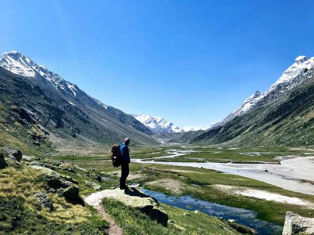
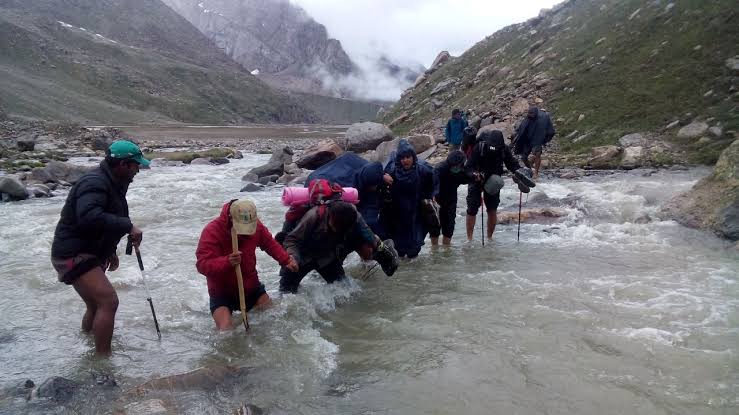
Today is going to be the most thrilling day of your life for sure and a little longer. Campsite for the day is Odi Thatch and one may ask so what’s special about Odi Thatch that makes it so thrilling. Well, it’s not Odi Thatch but the two bridges that we will be crossing today that makes the day special. The trail begins with a mild ascent and then rises steeply before you reach the first bridge. Once you descend down to the stream there is a huge boulder which acts as a bridge, Pandu Pul-1 for this stream. Once you cross over to another side of this stream and think that adventure is over you will encounter another 20 feet boulder which is on Parvati river and this is your second bridge, Pandu Pul-2. After crossing Pandu Pul the trail is a straight walk till Odi Thatch. This trail is frequently used by shepherds and there are many offshoots from the main trail. So be extremely careful here and never lose sight if the person ahead of you. Odi thatch is a vast flat pasture in the valley and if one is a Sci-Fi fan can easily relate this place to some interplanetary travel.
Day 6: Odi Thatch to Mantalai – 3700m- 5 to 6 hours
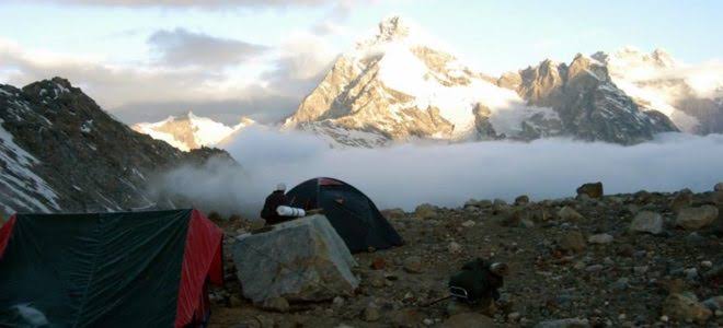
If the day before was the most thrilling, then, today is going to be the most enjoyable. The trail for today is pretty straightforward and there are practically no ascents or descents except the last 300 mts to the lake. The entire trail is a walk alongside river Parvati. You will be a seeing the river Parvati in its infancy and it’s a huge transition from the day we embarked on this journey. It’s hard to imagine that it’s the same river that could send shivers down the spine of even the toughest at the mere glimpse from the wooden bridge at Rudranag. Midway there is place often called mini Mantalai by the locals where the thousands of tiny streams are flowing over a vast expense of flat land and this is the where mighty Parvati is still in embryonic stage. After we cross mini Mantalai there is a steep climb of about 300 m. This is the final assault and can be negotiated pretty quickly. After this ascent is over we reach the glacial lake Mantalai. Here we will set our camp for the day. It’s an amazing campsite on the shores of Mantalai surrounded by mighty Himalayas.
Day 7: Mantalai – Base Camp I of Pin Parvati Pass - 4940m - 5 to 6 hours
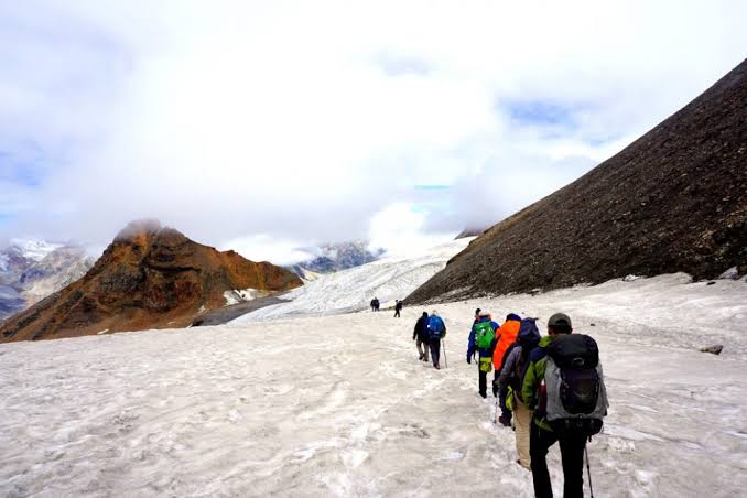
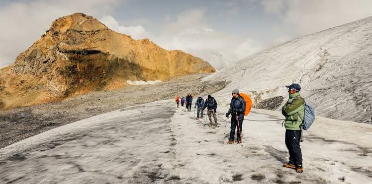
We are in for a challenging day today. We will take an early start and as we leave Mantalai Lake sun might just be rising over the mountains. There is a muddy steep section to begin with, here rocks and pretty loose so maintain a safe distance from the trekker ahead of you. Once this muddy section is negotiated the trail is over a spur and there is a fairly good ascent. Trail after crossing this spur eases out with gradual ascent till you hit the moraine area just 1 Km from our campsite for the day. This moraine section is just 1 km but it takes a little while to get through it. Climb during this section is pretty steep and hence require patience. As soon as you reach the campsite you will realize that we are camping just at the edge of Parvati glacier (approx. 300m). It’s a sight to behold and moonlit clear nights is always a cherry on the cake.
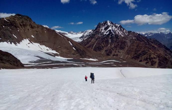
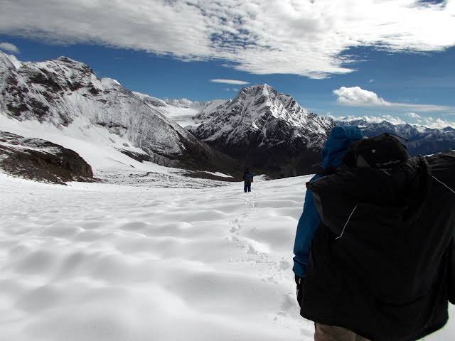
Day 8: : Base Camp I over the Pass - 5300m - Base Camp II - 4900m 7 - 8 hours
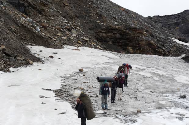
D-Day has arrived and we have to start real early today when the ice/snow is still firm and hence easier to walk on. Today we will cross the Might Pin Parvati pass over to another side into Spiti valley. So take a good look around the Parvati valley one last time as you were here for the last 6 days. Since today we will be negotiating around 3 km of glacier walk, be exercise extreme caution today and follow the trek leaders’ footstep all the time. On a glacier sometimes there are hidden crevasses which are very dangerous. Once this glacier section is over there is a steep climb of around 300-400 m just before the pass. Once you reach the pass take a deep breath and congratulate yourself for achieving this great feat. Yes, it’s you who has done it, it’s you who reached 17000 ft on your own. After spending some time here we will leave our campsite for the day which is about an hour or so from the pass. The trail descends gradually for around 1.5 Km to the campsite.
Day 9: Base Camp II to Wichkurung Thatch - 3500m - 6 hours
Today we have to reach Wichkurung Thatch our penultimate campsite for the trip. The trail descends down sharply for around 3Km. Be extremely careful and maintain a gap from trekker in the front. Always ensure firm footing before making the next move. After around 1.5 km there is a stream crossing, after that the decent still continues. After around 3 km into the trail we will cross the river to other side and continue our trek on this side of the river till we reach Wichkurung Thatch. Trail after crossing the river is pretty flat and hence a welcome breeze after 2 tough back to back days.
Day 10: Wichkurung Thatch - Mud - 3970m - 5 hours trek - Kaza by taxi
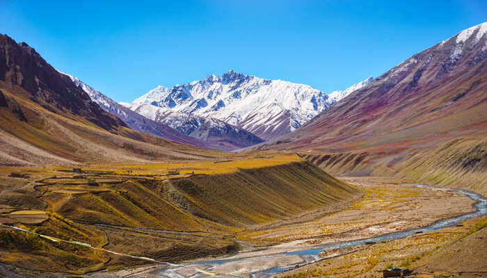
The trail today enters a wide-open valley with numerous streams and leads into the ancient Mud village in the Pin valley of Spiti. From mud village, we drive in a taxi to reach Kaza. We will spend the night in a hotel. Rooms will be on twin or triple sharing basis. About Kaza: Kaza is popular with tourists and adventure seekers during summer months because of its central location and connections to the rest of the valley and outside. This central location also makes Kaza an ideal base camp for trekking, mountaineering, and tours directed to other parts of the valley. Some of the major tourist attractions in and around Kaza beside Tangyud Monastery are the Key Gompa, Kibber village at an elevation of 4205 m. above MSL, Gette Village at an altitude of 4270 m above MSL, Langza village famous for the presence of marine fossils, the Pin Valley National Park, a protected area for Himalayan high altitude wildlife and the Losar village 40 km to the north of Kaza at an altitude of 4079 m above MSL.
Day 11: Kaza - Manali
After breakfast get ready for a long road journey to Manali. Drive in a taxi from Kaza to reach Manali by the evening. The trip ends here.
Leave Your Comments