Bali pass trek is for those who wish to hike to different and less travelled paths. Even though it is difficult it's every step is worth it. It challenges us in every way through drastically changing terrians, narrow paths, dangerous descend, long hours of walking. Of historic, religious, mountaineering, importance Bali pass trek is nothing like any other Himalayan trek. It is a walk into the unknown of the known.
Bali Pass
Rs 18,500.00 / Per person
- Region:Uttarakashi, Uttarakhand
- Altitude:16,200 ft.
- Duration :8 Days
- Distance:60km
- Difficulty :Easy to Moderate
- Best Time :Oct to Nov.
Basics Gears
• Backpack & Rain Cover (40-60 Litres)
• Trekking Shoes
• Trekking Pole
• LED Torch
• One Water Bottle (one litre)
• Basic Medications (or prescribed if any)
Clothes
• Trekking Jacket
• Three (Five in winter) Warm Layers
• Two trek pants (one Wear and one carry)
• Two collared t-shirts
• Thermals
Accessories
• Sunglasses
• Sunscreeen Lotion (SPF 50/70)
• Lip Balm (SPF 30)
• Sun cap
• Synthetic hand gloves
• Two pair of Socks
• Raincoat/Ponchos
Others
• Daypack (20 litres), if you opt to offload your backpack
• Toiletries
• Cutlery
• Plastic cover (for wet clothes)
Mandatory Documents
Original and photocopy of government photo identity card- (Passport, Aadhaar Card, Driving license or voters ID, Medical Certificate)
1
Day 1: Arrive in Sankri
Report in Sankri by 3 PM. Sankri is a tiny but a scenic town located in the region of Govind Pashu national park in the Uttarkashi district of Uttarakhand. It is around 195 km away from Dehradun. Private taxi takes around 6 hours to reach Sankri whereas bus takes around 8 hours to reach the same. Night stay & dinner will be provided by us. Stay will be arranged at a Guest house/Homestay.
2
Day 2: Sankri to Taluka
Sankri (1920 M) - Taluka (2107 M) 12 Kms by Road & Trek from Taluka - Seema (2560 M), 12 km (6-7 Hours)
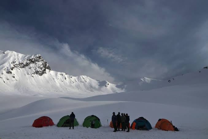
Early morning drive from Sankri to Taluka in a Taxi. The time taken for the drive is about 1 hour. Taluka is the starting point of our trek. After Breakfast at Taluka, we will start trekking with packed lunch for Seema Camp (2560 M) on an even surface through thick forests of chestnuts, walnuts, willows, chinars and a variety of conifer trees. You will find a few waterfalls on the way. You could either opt for the steep climb of Dhaatmeer village or just trek along the Karmanasha stream. Both the routes meet at Gangaar village. Reach Seema Campsite by late afternoon. Overnight stay in tents.
3
Day 3: Seema Camp (2560 M) to Rainbasera (3086 M) - 9 km trek (4 hours)
Today also, the trek is along the Supin river. First milestone is Debshu Bugyal, from where we will get a magnificent view of Kala Nag or Black Peak. After crossing Debshu Bugyal, we will descend through the forest with loose stones and sandy path to the river. We will cross the Supin river through a bridge. After crossing the bridge, we will again ascend with the Supin river flowing now on our right. There are a couple of tricky sections with slippery path where we might have to take a diversion. Trek along the river until we reach our campsite, which is by the side of the river. Overnight stay in Camps.
4
Day 4: Rainbasera (3086 M) to Ruinsara Tal (3565 M) – 7.5 km (4 hours)
This will be our last day when we walk along the Supin river. Today we will reach Ruinsara Tal by afternoon. Ruinsara is a lovely lake surrounded by meadows and rhododendron bushes. The trail is not difficult but it is tiring. The campsite is beautiful and we will have a chance to stay in wooden huts instead of camps. On one side of our camps is tiny lake of Ruinsara and on the other side is Supin River. The view from the campsite is mesmerising. On the south-west of Ruinsara Tal is Yamuna Kanta, the pass which takes you to Yamunotri and is rated as a difficult trek. To the east is the majestic Banderpooch Peak (6,387 m). The views of Dhumdhar Kandi (5,873 m) to the east, and Kala Nag (6,387m) and White Peak (6,102m) to the south-east are spectacular.
5
Day 5: Ruinsara Tal (3565 M) to Odari (4008 M) - 4 km (3 hours)
Today is a short and easy trek of about 4 km. Initially we descend down to Supin river through the dense vegetation. Crossing the river through a bridge, we will then ascend to a small meadow and then head south east along the river. After a trek of 3 kms or so the trail meanders towards south west. Walking for a kilometre from here brings us to our campsite Odari. Odari means a naturally made rock cave. According to folklore, it is believed that Bali (Hanuman's brother) stayed in this cave for one night. The views from the campsite are spectacular. In the North East we will have the crystal clear view of mighty peaks of Swargarohini 1 & 2. In the later half of the day the learning sessions will be conducted for the participants on techniques that might be of use in the coming days.
6
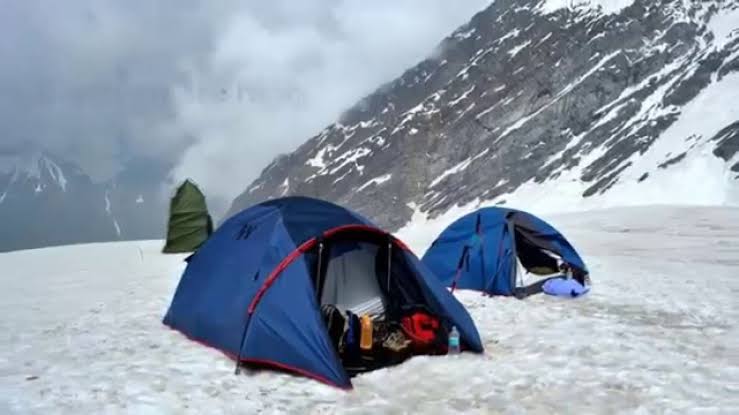
Day 6: Odari (4008 M) to Base Camp (4678 M) - 3.25 km trek (3 hours)
The day starts with a short hike south west to the base camp, but this hike would not be an easy one. We will have to walk on a mountain ridge with a 60 degree incline full of loose stones. This day is critical as we will be camping at a height of 4678 Metre. It is important to keep yourself active & hydrated to avoid chances of getting AMS (Acute Mountain Sickness). The temperature will drop to subzero levels increasing the difficulty many folds. Acclimatisation also takes longer at such heights. Overnight stay in camps.
7
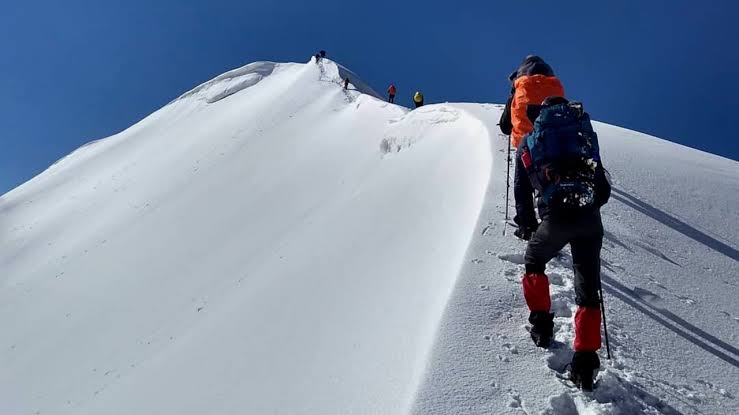
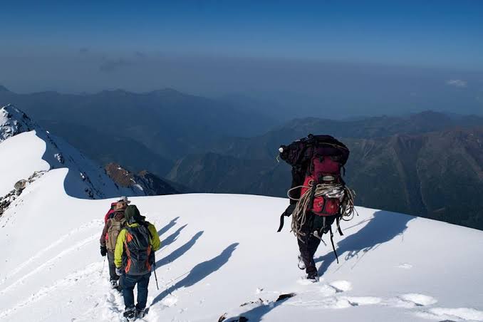
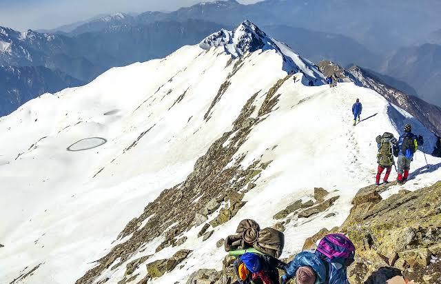
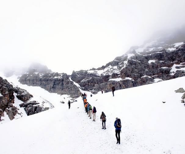
Day 7: Base Camp (4678 M) to Lower Dhamni (3415 M) via Bali Pass (4950 M) - 10 km (8-10 hours)
Today is the day because we will cross the Bali Pass (4950 m) and reach our next and also the last campsite, Lower Dhamni. We head south east towards the pass. Today's trek will be longer and the most challenging one. We will break camps and start trekking early in the morning at around 6 AM. The trail upto the pass remains full of snow which will require using the techniques learnt earlier. It will take around 2-3 hours to reach the pass from the base camp. Once we reach the pass, enjoy the 360 degree view of peaks such as Swargarohini, Banderpooch, Garhwal ranges and the Yamnotri valley. The most interesting as well as the difficult part of the trek starts after crossing the Bali Pass. We will descend down through a nearly vertical path full of scree and big stones. After crossing this leg, we will come across the goat route. To cross this leg, one needs to be mentally prepared because we will walk on an irregular path which is 6 inches or less wide in some places. After this extremely challenging part, we will rest for a while at a site called Upper Dhamni. After taking rest, we will resume our trek to Lower Dhamni. The path is a confusing one and therefore it is advised to stay with your trek leader and team.
8
Day 8: Lower Dhamni (3415 M) to Jaan ki Chatti (2650 M) via Yamunotri - 9.5 km trek
This will be our last day of trek. Initial trail is through forest which then merges into a cemented path. The trail is 4.5 km long with mild ascent upto Yamunotri. It will take around 1 hour and 30 minutes to reach Yamunotri. After reaching Yamunotri, you may take a dip in the Sulphur hot water springs of Yamnotri. Bathing in the hot water springs will take away the pain in your legs. From the shrine of Yamunotri we will take the regular pilgrims route to Jaan Ki Chatti which is around 5 km. Overnight stay in Jaan Ki Chatti guest House.
9
Day 9: Departure from Janki Chatti
The participants leave from Janki Chatti to Dehradun. Those who opt for transport with with us, they assemble at 7 am and leave for Dheradun. Participants who do not opt for transport with us can take a shared cab from the taxi stand.
Leave Your Comments